Heimaey, the largest island in the Westman Islands (Vestmannaeyjar) off the south coast of Iceland, had a catastrophic eruption in 1973. This changed the landscape of the island and the lives of the people living there. This article will look into the prophecy that foretold the disaster, the eruption itself, the evacuation and the aftermath and how the Heimaey community came together.
An old prophecy had been hanging over Vestmannaeyjar for centuries saying that pirates would once again raid the islands if three things happened:
In the beginning of 1973 all three of these conditions were met. The town had gone beyond Hásteinn, Vilpa pool was filled in after a young boy had drowned there and Karl Sigurbjörnsson, the son of a bishop, was ordained as a priest in Vestmannaeyjar. Instead of pirates, the islanders got a more severe natural disaster – a volcanic eruption.
Around 20:00 on January 21, 1973 small earthquakes started to occur around Heimaey. Although the inhabitants didn’t feel them, a seismograph 60 km away on the mainland registered over 100 big earthquakes between 01:00 and 03:00 on January 22. The earthquakes seemed to be coming from south of Heimaey and continued until 11:00 that day and then stopped until 23:00 that evening. From 23:00 until 01:34 on January 23 seven earthquakes were recorded, getting shallower and stronger as the epicenter moved closer to the town of Vestmannaeyjar. The biggest one measured 2.7 on the Richter scale.
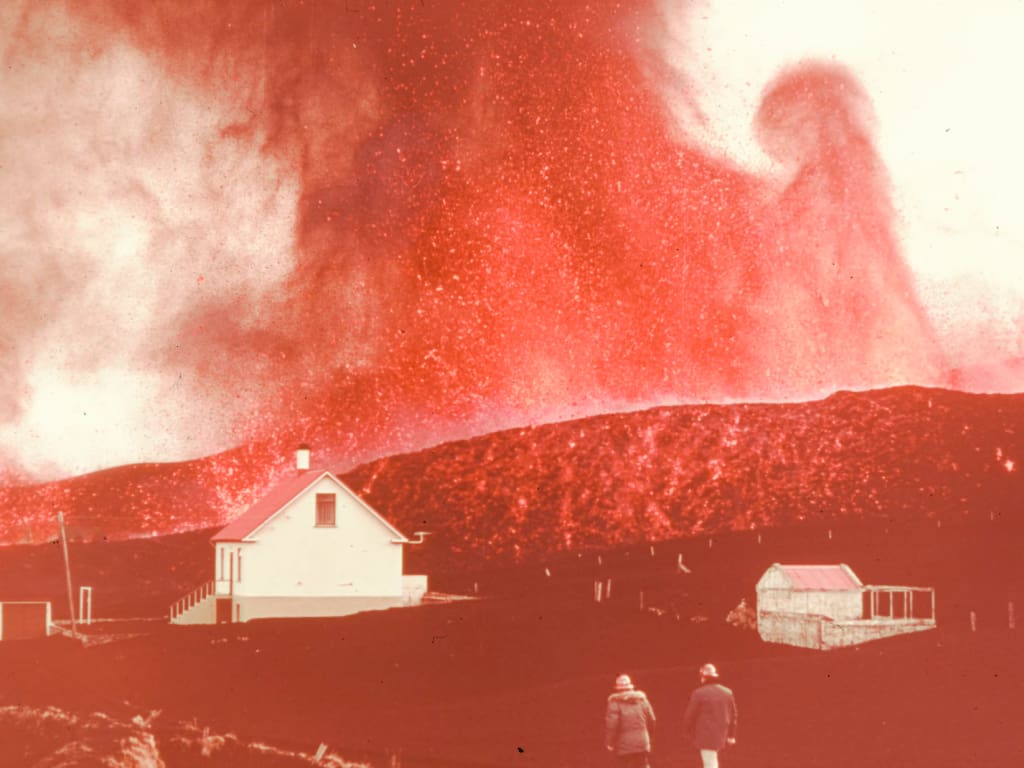
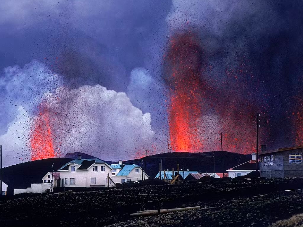
Although the warning signs were there, the eruption was almost a surprise. At 01:55 on January 23 a fissure opened on the eastern side of the island, just 1 km from the center of Heimaey. The fissure grew from 300 meters to 2 km long and crossed the island from one shore to the other. Submarine activity occurred at the northern and southern ends of the fissure. Lava fountaining 50-150 meters high occurred along the whole fissure which was 3 km long in the first few hours of the eruption. The volcanic activity was intense with lava fountaining 50-150 meters high along the fissure. The activity soon concentrated on one vent about 800 meters north of the old volcano Helgafell and just outside the eastern edge of the town.
In the first days of the eruption the rate of lava and tephra was 100 m3/s. Within two days the lava fountains had built a cinder cone 100 meters high. Initially named Kirkjufell (Church Mountain) because of its proximity to Kirkjubær, the official Icelandic place-naming committee named it Eldfell volcano (Fire Mountain) despite local opposition. The Strombolian eruptions continued until February 19, deposited tephra on the northern half of the island and added to the cone until it was 200 meters high. The eruption column reached 9,000 meters high, almost to the tropopause. Lava flows from the cone went north and east and created a growing lava delta along the eastern coast of the island and into the harbour.
The first lava from Eldfell was mugearitic but within a few weeks the volcano was erupting less fractionated hawaiitic lava. By early May the lava flow was 9.1-21.0 meters high, averaging 37 meters and in some places 100 meters thick. The flow carried large blocks from the main cone that had broken off and volcanic bombs. The high viscosity of the lava fragments created a massive ʻaʻā flow that moved slowly but surely north, northeast and east.
Gases were collected from several locations and showed that gases from cooling submerged lava flows were 70% hydrogen. Poisonous gas was found in low areas on the eastern part of Vestmannaeyjar. Efforts to divert the gas included building a wall and digging a long trench for steam to escape but it wasn’t fully effective.
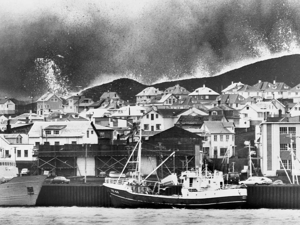
In the first hours of the eruption the Icelandic State Civil Defence Organisation evacuated the whole population of Heimaey. Because of the storms in the days before the eruption almost the whole fishing fleet was in the harbour so the evacuation was very quick. The population was alerted to the situation by fire engines sounding their sirens and the people gathered at the harbour with only what they could carry. The first boats left for Þorlákshöfn at about 02:30, just 30 minutes after the eruption started.
Most of the population left the island by boat. Luckily the lava flows and tephra fall didn’t affect the airstrip (Vestmannaeyjar Airport) so a few people, mostly elderly and hospital patients, could be evacuated by air. Planes from Reykjavík and Keflavik helped to speed up the process. Within 6 hours of the eruption the whole of the 5,300 population was on the mainland. A few people stayed behind to do essential work and to salvage belongings from threatened houses. Livestock on the island was slaughtered and the evacuated population found shelter and housing on the mainland with friends, relatives and strangers.
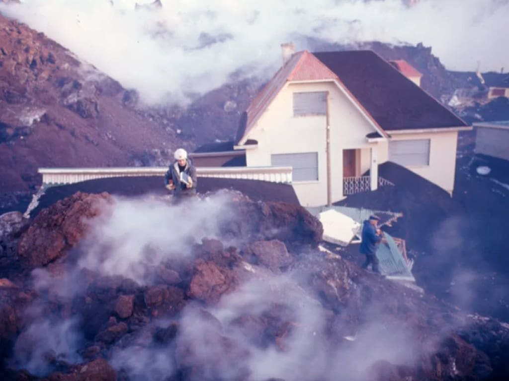
Houses close to the rift were destroyed by lava flows and tephra fall within days. A few days after the eruption started the wind direction changed to west and tephra fell all over the island and caused a lot of damage to property. Many houses were destroyed by the weight of the ash fall but crews of volunteers who cleared ash from roofs and boarded up windows saved many more. By the end of January tephra covered most of the island, up to 5 meters deep in some places. Some houses were also burned by lava bombs or overridden by the advancing lava flow.
By early February tephra fall had subsided but lava flows were causing damage. Submarine activity just north of the fissure cut an electric power cable and a water pipeline from the mainland which supplied electricity and water to the island. Lava was flowing towards the harbour and threatened the fishing industry, which is the lifeblood of the island. The island's fishing fleet played a crucial role in the swift evacuation process during the natural disaster, highlighting its importance to the community. If the harbour was blocked the impact on the Icelandic economy would be big as Heimaey was responsible for about 3% of the country’s GNP. Efforts were made to save the harbour by spraying seawater onto the lava flows to cool and slow them down.
Lava flows also flowed into the sea east of the island and created new land, adding over 2 km² to the island’s area. The flows were thick and blocky ʻaʻā lava, covering the ground to an average depth of about 40 meters, up to 100 meters in some places. Later in the eruption a surge of lava destroyed a fish processing plant and damaged two others and the town’s power generating plant.
Despite the eruption being so close to the town and the damage to property, only one fatality was caused by the eruption – a man who suffocated from toxic fumes after breaking into a chemist’s store to get drugs. Carbon dioxide and other poisonous gases accumulated in buildings partially buried by tephra and affected several people who entered these buildings.
Mitigation efforts included building a big tephra wall to divert gases and digging a trench to channel away carbon dioxide. These measures were only partly effective as some gases came from deep within the volcanic conduit and percolated through older volcanic rocks and rose directly into the town.
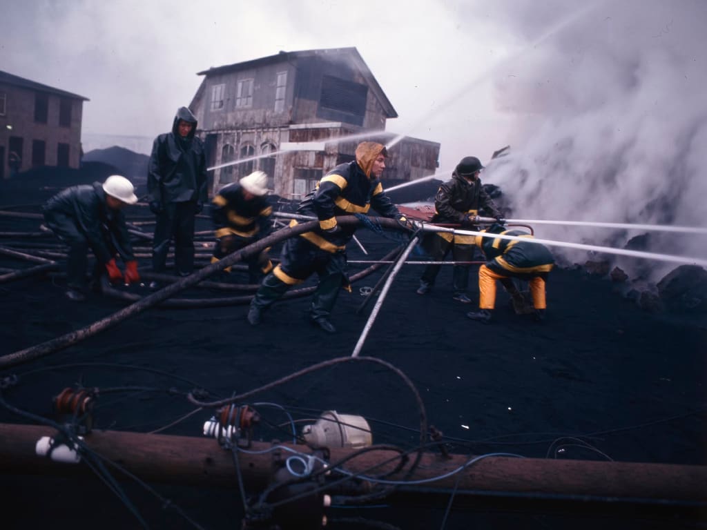
The biggest threat was the lava cutting off the harbour. One contingency plan was to cut through a low sand spit on the north side of the island to create a new entrance to the harbour. But efforts focused on cooling the lava to prevent this from happening. Lava had been sprayed with water in Hawaii and on Mount Etna with limited success. But Professor Þorbjörn Sigurgeirsson’s experiment showed that cooling the lava would slow it down.
The first attempt to cool the lava flow was on February 6 with 100 liters of seawater per second. It worked and the flow changed from blocky and red to jagged and grey. With cooling of the lava proven to work, efforts were increased. By early March the dredging boat Sandey was brought in to spray up to 400 liters per second onto the flow. The wooden supports for the pipes caught fire where the lava was hottest and the aluminum supports melted but the pipes themselves didn’t melt as the cold seawater flowing through them kept them cool.
The lava cooling operations were the biggest ever done. Up to 12,000 square meters of lava flow could be cooled at a time and internal barriers created within the flow would thicken and pile up on top of each other. It was dangerous work with low visibility due to steam emissions. The pipelayers were nicknamed ‘The Suicide Squad’ and they advanced through the steam to lay more pipes, managed to lay pipes up to 130 meters into the flow.
By the end of March a fifth of the town was covered by lava flows. More pumping capacity was needed and thirty-two pumps were brought in from the US. These pumps slowed down the lava flow and by early May the flow stopped. The entire cooling operation cost around $1.45 million.
The lava cooling operation worked and the harbour was not blocked. The eruption made headlines around the world and got a lot of coverage especially for the innovative measures to stop the lava flows. The eruption led to an increase in tourism, as the innovative measures to stop the lava flows attracted global attention. The island’s response to the eruption brought an increase in tourism after the eruption was over.
The lava output decreased steadily after the first few days. From 100 cubic meters per second in the beginning to 60 cubic meters per second on February 8 and 10 cubic meters per second by mid-March. By mid-April it was down to 5 cubic meters per second. A short-lived submarine activity was discovered by a fishing vessel on May 26 north east of Heimaey. The eruption ended in early July but subsurface flows may have continued for a few days more.
In total the eruption emitted around 0.25 cubic kilometers of lava and tephra and added about 2.5 square kilometers of new land to the island, increasing the area by about 20%. The harbour entrance was narrowed but not blocked and the new lava flow acted as a breakwater and improved the harbour. The lava chunk called Flakkarinn stopped well away from the water’s edge and didn’t cause any further damage.
By the end of 1975 the population of the Westman Islands was back to around 85% of the pre-eruption level. Of those who had houses destroyed 42% didn’t return and 27% of those who didn’t have their houses destroyed returned. The recovery efforts were often hampered by bad weather, including strong winds and heavy rain, which made transportation and rebuilding efforts more challenging. By 1974 the fishing companies in the Westman Islands were back to normal production. The new lava field improved the harbour and the forced displacement had a positive effect on the income and education of those under 25 years old at the time of the eruption.
The inside of lava flows can stay hot for many years. After the eruption scientists assessed the possibility of utilising geothermal energy from the cooling flows. By 1974 the first house was connected to an experimental heating system. By 1979 four bigger plants were built to extract heat from the flows and produced up to 40 megawatts of power and hot water for almost every house on the island.
The tephra from the eruption was used to extend the runways at the small airport on the island and as landfill for 200 new houses. By mid 1974 about half the pre-eruption population had returned and by March 1975 about 80% had returned. The recovery and reconstruction was funded by a hypothecated sales tax paid by all Icelanders and international aid of $2.1 million, mostly from Denmark and the US. The improved harbour allowed the fishing industry to get back to normal and Heimaey became the most important fishing centre in Iceland.
By the end of the eruption Eldfell was about 220 meters above sea level. Since then it has dropped 18-20 meters due to slumping, compaction and wind erosion. The islanders have planted grass around the lower slopes of the hill which is otherwise bare. Eventually most of the volcano will be covered in grass like its neighbour Helgafell.
The 1973 eruption was a turning point for Heimaey and the Westman Islands. It changed the physical landscape, tested the people and left a lasting legacy that still affects the island today. From the efficient evacuation and heroic efforts during the eruption to the amazing recovery and innovations that followed the story of Heimaey is a proof of human resilience and the ability to rebuild after natural disasters.
The lessons from the 1973 eruption are still used in disaster preparedness and response worldwide. The geothermal energy and urban planning innovations are a model for sustainable development in other disaster prone areas. The ongoing research and educational programs ensure that the knowledge from this event is passed on to future generations.
For the people of Heimaey the eruption is more than just a historical event; it's a living memory that shapes their identity and community spirit. Annual commemorations, museum exhibits and educational programs make sure the story of the eruption and the people of the island is never forgotten.
Come and visit Westman Islands, including Heimaey and see this special island and its history. The dramatic landscapes created by volcanic forces give a glimpse into the natural forces that are still shaping our world. The friendly community, resilient and innovative, is the spirit of adaptation. Take a boat tour around the island to explore the rugged coastline and experience local marine life, including whales, dolphins, and seabirds. Heimaey is a proof of human strength against nature’s power.